
Silk Stream bridge - a step too far
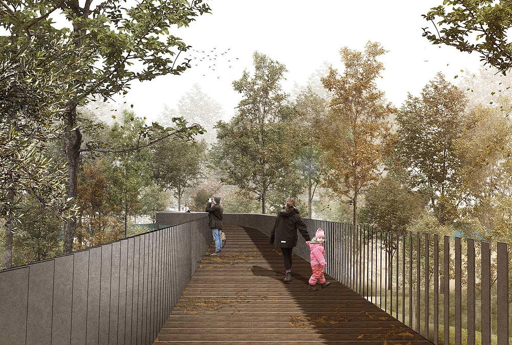
Artist’s impression by bridge architects, Makower Architects
Due to be built by Barratt Homes in 2023 as part of the Hendon Waterside regeneration programme in North West London, a controversial new 186-metre footbridge is set to cross the protected north marsh of the Welsh Harp (Brent Reservoir) — a Site of Special Scientific Interest (SSSI) since 1950. It will destroy existing fragile habitat in order to link a new housing development with a sports hub.
Planning permission was granted by Barnet Council in 2018 with conditional approval by Natural England against a raft of objections from leading bodies including London Wildlife Trust, Canal and River Trust and RSPB.
Using new evidence and recently unearthed archive photographs, here we show why it still should not go ahead as planned.
Misleading images
“The new pedestrian bridge,” says the official description in the original planning documents, “will be located in woodland to the north of the reservoir and will span the Silk Stream which is one of two watercourses that flow through the reservoir. The bridge will be c. 186m in length and facilitate pedestrian access between the West Hendon Estate and open space to the north west. It will be constructed of prefabricated units, suspended on paired steel piers which themselves will be stabilised by piles driven into the woodland floor.”

Drawing of new footbridge from planning documents
Looking at the bridge route (shown above in pink with the construction site outlined in red), it would seem obvious that 90% of the bridge passes over land (the ‘woodland’ referred to in the planning description, shown in white), with seemingly little impact on the reservoir (in blue).
So what’s the problem?
The problem is that in the real world much of the land depicted is not land at all, nor even ‘woodland’, but the forgotten overgrown wetlands of the north marsh SSSI bird refuge — precious legally protected habitat built from 1985-1990 with public money, but left unmanaged for decades by statutory bodies potentially in breach of environmental law. The shape of Welsh Harp reservoir and its north marsh bears no relation to this drawing. In fact, such is the extent of open water, you could even take a boat into sections shown as dry land.
You might even be forgiven for thinking the drawing was deliberately created to give the impression the bridge will mostly cross over a nondescript area with little impact on the reservoir or SSSI.

Aerial impression from the planning documents
In this second image (above) also from the planning documents, again the bridge is made to look as though it passes through dense woodland, with the reservoir further to the south east.
In fact, the reservoir — although now heavily overgrown in places with colonised vegetation — stretches right up as far as the large white square warehouse (below the words ‘W Hendon Broadway (A5)’). Chronic neglect, silting and willow encroachment has allowed a canopy to develop over the landscaped wetlands in this area, making it look like woodland from above. It is not. It is legally protected open water, islands and screened breeding bird habitat that, owing to natural succession — allied to decades of poor stewardship — has now partially morphed into a jungle of wet woodland (the transition zone between open water and drier ground).
And yet, despite its protected wetlands origins, the Barnet Council Decision Notice granting approval for the bridge — and the influential executive summary of the Ecological Assesssment written in support of the original plannning application — each use the broad, and arguably misleading single term ‘woodland’ 88% of the time to describe the area.
It is not until page 19 that the Ecological Assessment admits, “The woodland floor comprised a matrix of pools and wet channels with trees and vegetation growing on islands of slightly higher ground.”
We say, of course it does. It is not a woodland floor at all. It is the neglected wetlands and bird refuge of a protected SSSI.
The forgotten reality
Looking at this aerial photo taken in the early 1990s, the open water and islands and lagoon of the original SSSI remodelling — built with major funding from the GLC to support wildlife and a nationally important breeding bird population — clearly stretch to the top of the image.

Aerial photo taken shortly after SSSI wetlands were created in 1985 . The corner of the warehouse in previous image is just visible at the top of the image.
It is not woodland, not even wet woodland, but thriving wetlands. The area has since suffered decades of neglect with largely only volunteers and local conservationists fighting for its proper stewardship.
To make it even clearer, the three photos below show the north marsh looking towards the mouth of the Silk Stream before and after completion of habitat and management works in the 1980s.

In all, the protected wetlands SSSI habitat with its islands, pools and open water is clearly visible, and yet the Barnet Council Decision Notice and the Ecological Assessment make no mention of it, successive authorities have neglected it and the proposed footbridge will cut across it.
The real impact
The Ecological Assessment used in the planning application asserts:
“Embedded design features include siting of the bridge as far north as practical to ensure a substantial woodland buffer between the bridge and the open water of the northern arm of the reservoir”.

Superimposition of new footbridge across actual shape of SSSI north marsh wetlands.
The superimposition image above shows this is not true; the bridge will actually pass right through the neglected northern arm of the reservoir across a SSSI bird refuge in desperate need of restoration. There is no natural ‘woodland buffer’, only overgrown protected wetlands.
On their website, the bridge architects Makower Architects even go so far as to inexplicably rename this part of the reservoir ‘the flood plain of the Silk Stream’; they also call the Welsh Harp a ‘nature reserve’ but fail to mention the reservoir and its boundary has been a SSSI since 1950, and claim the bridge ‘runs around’ it.
We say planning permission for this pedestrian bridge has been granted using grossly misleading information and the real impact has not been accurately represented to the public.
Is it too late to save the wetlands?
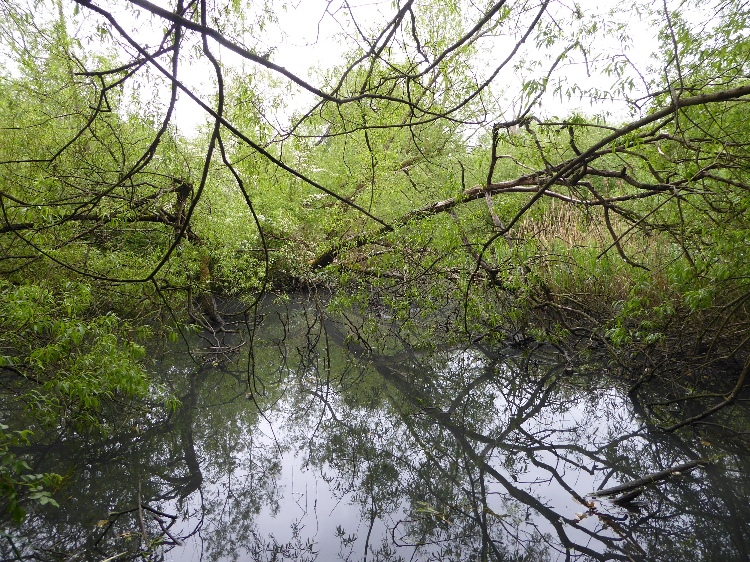
We say no. The next four photographs taken in May 2021 clearly show that thirty years on large areas of open water and most of the landscaping still exist, if overgrown and hard to reach in places due to colonisation of vegetation. It is certainly not the littered nondescript woodland and dry land used to make the case for the route of the bridge.

Abandoned north marsh wetlands, May 2021
To run a 186-metre bridge over this area would only add insult to environmental injury: not only have the wetlands been wrongfully neglected for too long by successive statutory authorities, but the proposed construction would further damage them, and in so doing damage the protected features of a SSSI in potential breach of environmental law.

Abandoned north marsh wetlands, May 2021
No one should need reminding that the Welsh Harp (Brent Reservoir) has been designated a Site of Special Scientific Interest (SSSI) since 1950, notified primarily for breeding wetland birds, the diversity of wintering waterfowl and rare fenland plants. Many species of waterbird have seen local breeding numbers drop by as much as 80% since 2000. Many rare plants have disappeared. Thirty years of habitat neglect by successive statutory bodies has without doubt contributed to this. And yet none of the three landowners — Barnet Council, Canal and River Trust, Brent Council — hold an official list of protected flora and fauna, or a map of invasive species, or robust plans to reverse falls in protected bird numbers; Barnet Coucil don’t even have an ecologist, a biodiversity officer or any biodiversity plan. In the meantime the north marsh SSSI bird refuge — a haven of islands, pools, scrapes and quiet breeding areas — has been allowed to become a lost jungle.

Abandoned North Marsh Wetlands, May 2021
In spite of this, the Ecological Assessment used in the planning application manages to conclude: “Based on implementation of the Construction Method Statement and delivery of the embedded mitigation and enhancement measures no significant effects on important ecological features will occur as a result of the construction and operation of the Silk Stream pedestrian bridge.”
Abandoned north marsh wetlands, May 2021
Environmental law
Here are a few key points of law that are worth keeping in mind when considering the damage that will be done by the building of the new bridge.
Environmental law clearly states “It is an offence for a public body to fail to minimise damage done to an SSSI or — if damage occurs — to fail to restore an SSSI to its former state”.
It also states “Statutory bodies have a general duty to take reasonable steps to further the conservation and enhancement of the special feature of SSSIs.”
It also states “it is an offence to intentionally or recklessly destroy or damage the listed features of a SSSI or disturb its listed fauna, without reasonable excuse”. This explicitly includes local authorities — in this case Barnet Council.
All public bodies are also legally beholden under the Natural Environment and Rural Communities Act of 2006 to their “Biodiversity Duty” which includes “restoring or enhancing” a habitat.
Time for change
Notwithstanding issues of environmental law, it is also clear times, priorities and public sentiment have changed since planning was approved for the footbridge in 2018.
Not only has the COVID-19 pandemic of 2020 ushered in a new age of green awareness and mental health concerns driven by a public keen to re-engage with nature, but the UK parliament declared a climate emergency in May 2019 with over two-hundred councils pledging to work with partners and local communities on tackling key issues such as decarbonisation and improved biodiversity. These alone should make Barnet Council and Barratt’s seriously reconsider the current proposals for the Silk Stream Bridge.
What’s more, most of the residents newly installed in the Hendon Waterside redevelopment have no idea about this bridge; their opinions have not been polled as the bridge was approved before they moved in. Who says they want direct access to football pitches? Maybe they’d like to save a protected 70 year-old SSSI. Maybe they’d be prepared to walk a little further along a different route and have both.
As it is, for most residents the bridge will only save four minutes on the same journey along West Hendon Broadway to the same end point. Many might also deem a walk along the road as arguably safer, when compared with a 186m bridge, with no clear view to its opposite end, through a quiet wooded part of the reservoir. Especially as the light fades. Are Barnet Council and Barratt’s really prepared to wreck a historic protected wetlands in order to save residents four minutes on a bridge that might not get used?
Already 50m of nearby shoreline willow – crucial screening for breeding waterbirds – has been cut down to create a view for a new children's playground and a vista through the estate from the busy A5. If the bridge goes ahead as planned, it could quickly prove a huge misjudgment as an amenity, and the northern arm of the Welsh Harp — a fragile, legally protected wildlife habitat since 1950 —would be at further risk of becoming little more than an ornamental lake for private housing.
Is there a solution?
If a bridge is still deemed essential to the over all regeneration of the West Hendon estate and abandoning it completely is not an option, we say yes, there is a better solution.
At the time of the planning process an alternative less invasive northern route for the footbridge was supported by Natural England, London Wildife Trust, RSPB and local conservationists, but was rejected. It was, on reflection, disjointed and in part land-based, but perhaps crucially did not align with Planning Condition 27 — a pre-commencement condition which specifically states: “The Silk Stream Bridge ... should be designed with soffit set no lower than 600mm above the 1 in 100 year plus climate change flood event level and abutments set as far back as possible. The bridge should be of a clear span design over the watercourse, where this cannot be achieved this should be clearly justified by the applicant.”

Possible alternative routes minimising impact on wetlands
However, we propose a new solution in the illustration above — a raised bridge to meet conditions, but either curved or angled to swerve around the wetlands. (The open water of the wetlands is clearly visible between the tree canopy in this 2021 Google Maps image.) Saving the integrity of the SSSI wetlands should be ample justification for the new span design.
The wetlands — long overdue rehabilitation — could then be restored as part of the ecological mitigation works due after construction, and align with other Government-approved Blue and Green Recovery programmes and climate emergency targets across the UK.
Next steps
Barnet Council’s own blueprint for the future, the Local Plan 2012, states, “Developments should ... be sensitively designed so that there is no net loss in the quality and quantity of habitat across a development site, to enhance biodiversity and increase connectivity between patches of urban habitat.”
We say without a change in its alignment, a 186m bridge run right across the overlooked SSSI north marsh wetlands of the Welsh Harp risks a major loss of habitat far exceeding that represented in the planning application; it will also without doubt damage existing biodiversity, devastate remaining breeding bird numbers and cut in half a large patch of protected urban habitat.
It is difficult not to conclude the north marsh wetlands and the full footprint of the reservoir either went completely unrecognised during the consultation and planning phase — which is in itself a major ecological and historical oversight — or were imaginatively represented as woodland and partial wet woodland in an effort to draw attention away from their significance. We insist they cannot be ignored. They and the wildlife and plantlife they support are protected under environmental law.
We urge Barnet Council, Barratt’s and Natural England to acknowledge the presence of the neglected 1985 wetlands and re-assess the sheer scale of the ecological damage done by the proposed bridge, and we vigorously recommend a planning permission amendment is issued that alters the bridge’s alignment.
Without it, the project risks seriously misleading the public and potentially misreading its new-found post-pandemic environmental sympathies. It is also in danger of ignoring new government-driven climate emergency goals, Barnet Council’s own self-declared green commitments and the law by recklessly destroying the listed features of a landmark 70 yr-old SSSI.
If a case is made by Barnet Council and Barratt’s to retain the existing route regardless of the information provided in this report, and public outcry at the environmental vandalism is ignored, we urge Natural England to use their power of veto to impose the strongest possible conditions prior to construction regarding ecological mitigation measures that must be implemented by Barratt’s after the bridge is completed. This must mean extensive improvements and net biodiversity gain both around the bridge and in other parts of Welsh Harp to fully compensate for the previously unacknowledged vast loss of legally protected habitat that this report brings to light.